
 Visual simultaneous localization and mapping (SLAM) is a major advancement in embedded vision with a wide range of current and potential applications. Commercially, visual SLAM is still in its earliest stages of development. But SLAM addresses the limitations of many other vision and navigation systems and is projected to have rapid growth.
How Visual SLAM Works
Visual SLAM is less of its own technology and more the process of determining the position and orientation of a sensor with respect to its surroundings. SLAM can also simultaneously map the environment around that sensor. Because cameras are inherently 2D, 3D computer vision must use complex algorithms and deep learning to mimic true 3D vision.
SLAM uses 3D computer vision to perform location and mapping functions when neither the environment nor the location of the sensor is known. To determine 3D position, most visual SLAM systems track setpoints through consecutive images, also using this information to approximate camera pose.
All of this can be made possible with a single 3D vision camera. As long as enough points are being tracked through each frame, both the orientation of the sensor and the surrounding environment can be determined in real-time. This makes SLAM an excellent option for mapping environments for navigation purposes.
The Future of Visual SLAM
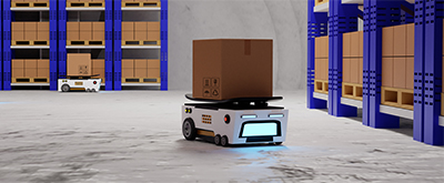
Visual SLAM is already being used in a number of field robots. Rovers and landers for Mars exploration use visual SLAM systems to navigate autonomously. In the agriculture industry, both vehicles and drones use SLAM to independently travel throughout fields. SLAM may soon be used by self-driving cars and trucks to navigate roads and highways.
SLAM will likely soon become a key part of augmented reality. To accurately project virtual images onto the physical world, a precise mapping of the physical environment is needed. So far, only visual SLAM is capable of providing the level of accuracy required.
Another major opportunity for visual SLAM is to replace GPS tracking and navigation. GPS isn’t very useful indoors or in large cities where the sky is obstructed. And GPS is usually only accurate within a few meters. Visual SLAM isn’t dependent on satellite information and can provide great accuracy while mapping the surroundings.
Are you ready to add quality machine vision cameras to your facility’s automation systems? Contact the experts at Phase 1 Technology Corp today.